


Barabanki At Glance
What is Live Barabanki
The land of Barabanki possesses a rich heritage in keeping with its glorious past. This district since its inception has been the meditorium for numerous saints and ascetics, sanctum of 'Sadhna' for the literary intellectuals and battlefield for the freedom fighters.
Barabanki Brought the whole world under one umbrella. Sufi Saint Haji Waris Ali Shah of international fame, motivated people through the message of JO RAB WAHI RAM i.e. The supreme power, God is One and is the flower of this fertile land. Satnami Saint Shri Jagjiwan Das and Saint Malamat Shah lit the torch of communal harmony for the countrymen at large.
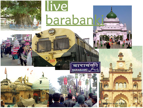
The Picture in itself signifies the love n harmony between the people of Barabanki and respect for every religion , festival or ceremony , despite of having difference in thoughts and way of style.
Barabanki was also known as the 'Entrance to Poorvanchal', has the privilege of being the penance ground to numerous saints and ascetics. Barabanki was known as Dariyabad with its headquarters at Dariyabad town established by an officer in the army of Mohammed Shah Shariqi by the name Dariab Khan. It remained the district headquarter till 1858 AD.
The district headquarter was shifted to Nawabganj in 1859 AD now known as Barabanki. This was done during the expansion of the district by the British, when Kursi from district Lucknow and Haidergarh from district Rae Bareli were added to the, then Dariyabad district.
 As per the historical documentation available, in 1030 AD this region was attacked by Sayyed Salar Masood, brother of Mahmood of Ghazni. In the same century Qutubuddin Gaha of Madina annexed the Hindu princely states, thereby establishing the Muslim dominance then on. During the reign of the great Mughal emperor Akbar this district was dividedly under the sirkars of Awadh and Manikpur.
Many kings and princes opposed the expansion of British rule into this district by waging wars against them. During the British Raj, several kings fought for their independence and laid down their lives doing so, the great revolutionaries ! Raja Balbhadra Singh Chehlari along with about 1000 revolutionaries sacrificed their lives for independence from the British rule.The last battle of the First War of Indian Independence was fought in December 1858 AD here in this district.
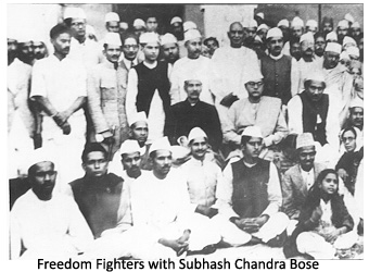
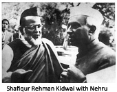
In 1921 AD Gandhiji started the Non-cooperation Movement, thereby igniting the flame of independence once again. Here too, the district leading from the front, opposed the arrival of Prince of Wales to India. As a result, protests were organised and large number of freedom fighter courted arrests at the Government High School, Nawabganj, Shri Rafi Ahmad Kidwai was also arrested.
During 1922 AD Khilafat Movement, 1930 AD Salt Movement, and in 1942 AD the Quit India Movement, the people of this district actively participated in these movements thereby giving sleepless nights to the British Raj. As a result, the District Congress Office was sealed. But, the local leaders continued their protests remaining underground. The Haidergarh Post office was looted on 24th August 1942 as a mark of protest by the revolutionaries. Similar incidents took place at the GPO Barabanki and Satrikh.

Geography
Location & Boundries
The district Barabanki is situated about 29 Kms. in the East direction of Lucknow the Capital of Uttar Pradesh. This district being one of the four districts of Faizabad division, is located in the heart of Awadh region and it lies between Latitudes 26° 30' North and 27° 19' North and Longitudes 80° 58' East and 81° 55' East. District Barabanki is surrounded by district Faizabad in the East, districts Gonda and Bahraich in the North East, district Sitapur in the North West, district Lucknow in the West, district Rae Bareli in the South and district Sultanpur in the South East. The river Ghaghra forms the North Eastern Boundary separating Barabanki from Bahraich and Gonda.
Area
According to the 1991 census the area of the district was 4401 sq. kms. The area is liable to vary from year to year due to the slightest change in the coarse of the river Ghaghra, because this slight variation makes a noticeable change in the overall area of the district.
Topography
The district can be topographically divided into three main regions. First TARAI region, the area in the North East towards river Ghaghra. Second GOMTI PAR region, the wide area from South West to South East of the district. Third is called the HAR region, which is situated at some height to the Gomti Par region. The whole tract is gently undulating land with gentle slope from the North West to South East.
Climate
The district lies in the plains of the State, and hence its climatic conditions are quite similar to the average climatic condition of the plains. Hot to very hot in summers, cold to quite cold during winters and humid to very humid and sultry during rainy season. Most of the rain occurs from June to September and often in November to January. The winter sets in November and continues till February end. The maximum temperature recorded in 1997-98 was 45.0°C and minimum was 2.5°C. The average rainfall recorded for 1997-98 was 1056 mm.
River Rait
Rait is a small stream which flows dangerously during rains, flooding its adjoining areas, but dries up during the summers.

